
Most Amazing Hot Springs Around the World
A hot spring is a spring that is produced by the emergence of geothermally heated groundwater from the earth's crust. There are hot springs all over the earth, on every continent and even under the oceans and seas. Many were created between 20 and 45 million years ago as a result of violent volcanic activity.
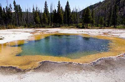
Silex Spring at Fountain Paint Pot
Silex Spring is located in Yellowstone National Park. Hot water is a better solvent than cooler water, dissolving large amounts of silica ? the major element of these volcanic rocks in the form of sinter lines the bottom of Silex Spring. It forms terraces along the runoff channels and gives the spring its name. The spring overflows most of the year, creating a hot environment where thermophiles thrive which become food for several kinds of flies that live in and on the hot water. The flies then become food for mites, spiders, various insects, and birds.

Emerald Spring
Emerald Spring is a boiling hot spring located in Norris Geyser Basin of Yellowstone National Park. Emerald Spring is 27 feet (8 m) deep. The water temperature in the spring is around 172�F (78�C). The spring gets its name the emerald green color of the water created by sunlight filtering through the water, giving the light a blue color, and reflecting off the yellow sulphur creating the green hue While Emerald Spring is a mostly calm pool, which usually only has a few bubbles rising to the surface, it does experience periods of turbidity and small 3-foot (1 m) high eruptions. In 1931, Emerald experienced a period of extremely vigorous activity with eruptions measuing 60 to 75 feet (18.2'22.9 m) in height
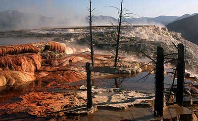
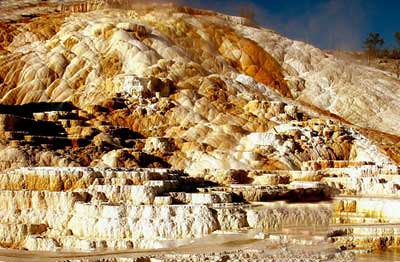
Mammoth Hot Springs
Terrace Mountain at Mammoth Hot Springs is the largest known carbonate-depositing spring in the world. The most famous feature at the springs is the Minerva Terrace ? a series of travertine terraces which have been created over thousands of years as hot water from the spring cooled and deposited calcium carbonate. Over 2 tons flows into Mammoth each day in a solution. Due to recent minor earthquake activity, the spring vent has shifted, rendering the terraces dry. A system of small fissures carries water upward to create approximately 50 hot springs in the Mammoth Hot Springs area. Although these springs lie outside the caldera boundary, their energy has been attributed to the same magmatic system that fuels other Yellowstone geothermal areas. Another major component for terrace growth is the mineral calcium carbonate. Thick layers of sedimentary limestone deposited millions of years ago by vast seas lie beneath the Mammoth area. As ground water seeps slowly downward, it comes in contact with hot gases charged with carbon dioxide rising from the magma chamber. Some carbon dioxide is readily dissolved in the hot water to form a weak carbonic acid solution. This hot, acidic solution dissolves great quantities of limestone as it works up through the rock layers to the surface hot springs. Once exposed to the open air, some of the carbon dioxide escapes from the solution. A solid mineral reforms and is deposited as the travertine that forms the terraces.
Blood Pond Hot Spring
Blood Pond Hot Spring is one of the "hells" (jigoku) of Beppu, Japan ? nine spectacular natural hot springs that are more for viewing rather than bathing. The "blood pond hell" features a pond of hot, red water, colored as such by iron in the waters. It's allegedly the most photogenic of the nine hells.

Deildartunguhver Hot Spring
Deildartunguhver is the largest hot spring in Iceland, located in Reykholtsdalur. It's characterized by a very high flow rate for a hot spring at 180 liters/second of boiling water and emerges at 206�F (97�C). It's the highest-flow hot spring in all of Europe. Some of the water is used for heating, being piped 21 miles (34 kilometers) to Borgarnes and 40 miles (64 kilometers) to Akranes.
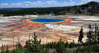
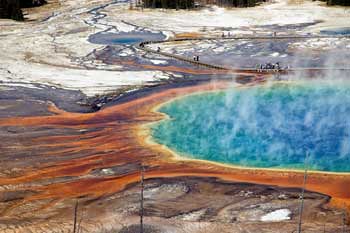
Grand Prismatic Spring
The Grand Prismatic Spring in Yellowstone National Park is the largest hot spring in the US and third largest in the world next to those in New Zealand, about 250 by 300 feet (75 by 91 meters) in size and 160 feet (49 meters) deep, discharging an estimated 560 gallons (2000 liters) of 160�F (71�C) water/minute. The vivid colors in the spring ranging from green to brilliant red and orange are the result of algae and pigmented bacteria in the microbial mats that grow around the edges of the mineral-rich water, the amount of color dependant on the ratio of chlorophyll to carotenoids produced by the organisms. The center of the pool is sterile due to extreme heat. During summer the chlorophyll content of the organisms is low and thus the mats appear orange, red, or yellow. But in winter, the mats are usually dark green because sunlight is more scarce and the microbes produce more chlorophyll to compensate, thereby masking the carotenoid colors. The deep azure blue color of the water in the center of the pool results from a light-absorbing overtone of the hydroxy stretch of water. While this effect is responsible for making all large bodies of water blue, it's particularly intense in Grand Prismatic Spring due to the high purity and depth of the water in its center.
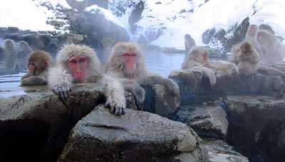
Jigokudani Hot Springs
Jigokudani Hot Springs in Nagano Prefecture, Japan is most famous for its so called "snow monkeys" ? wild Japanese monkeys enjoying the naturally hot waters alongside the human visitors The monkeys enjoy bathing especially during the cold winter months when temperatures drop below freezing, and the valley is covered by a thick layer of snow. But even in the summer they take occasional baths, sometimes allured by food thrown into the pool by park wardens. Jigokudani Yaen Koen or "Jigokudani Monkey Park" is the chosen home of more than 100 Japanese Macaques, Japan's indigenous monkeys. The park is located in "Hell Valley," named for the volcanic activities in the area.
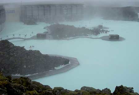
Blue Lagoon
The Blue Lagoon geothermal spa is one of the largest attractions in Iceland. The steamy waters are part of a lava formation, and a large swimming pool is heated with the run-off water from a nearby geothermal power plant Superheated water is vented from the ground near a lava flow and used to run turbines that generate electricity. After passing through the turbines the steam and hot water passes through a heat exchanger to provide heat for a municipal hot water heating system. The water is then fed into the lagoon for users to bathe in. The warm waters are rich in minerals such as silica and sulfur. Bathing in the Blue Lagoon for therapeutic purposes is reputed to help some people suffering from skin diseases such as psoriasis. The water temperature in the bathing and swimming area of the lagoon averages 40�C (104�F). The spa is located in a lava field in Grindav�k on the Reykjanes Peninsula, southwestern Iceland. It's situated about 24 miles (39 kilometers) from the capital city of Reykjav�k. The Blue Lagoon spa and geothermal complex is clearly visible from any of the usual satellite imagery. It was used for the thermal spa scenes in the filming of Hostel: Part II.
Most Amazing Satellite Pictures You'll Ever See
Ground Zero, New York City - Sept 12, 2001
This one-meter resolution satellite image of Manhattan, New York was collected at 11:43 a.m. EDT on Sept. 12, 2001 by Space Imaging's IKONOS satellite. The image shows an area of white and gray-colored dust and smoke at the location where the 1,350-foot towers of the World Trade Center once stood. Since all airplanes were grounded over the U.S. after the attack, IKONOS was the only commercial high-resolution camera that could take an overhead image at the time. 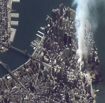
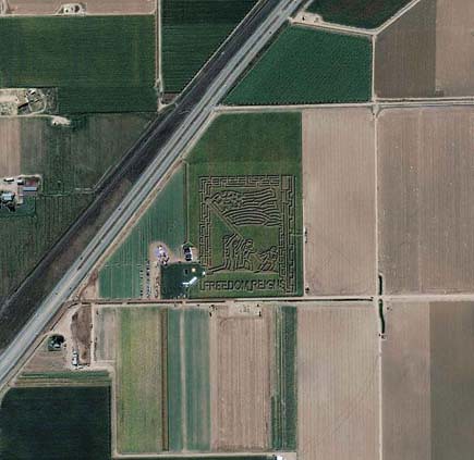
Fritzler Corn Maze, Colorado
Space Imaging's IKONOS satellite took this image of the patriotic Fritzler Corn Maze near Greeley, Colorado, September 18, 2004. The design depicts the U.S. Marines raising the American Flag at The Battle of Iwo Jima in World War II.
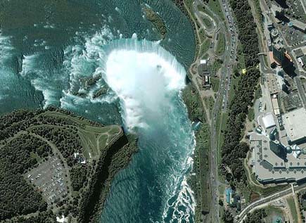
Niagara Falls
The image shows the Niagara River that connects Lake Erie to Lake Ontario, snaking around Goat Island, in the lower left of the full image. Most of the river's water plummets over the Canadian/Horseshoe Falls, but some diverted water spills over American Falls and Bridal Veil Falls downstream. Every second, more than two million liters of water plunges over the Horsehoe Falls segment of Niagara Falls creating one of the world's largest waterfalls as well as eating away as much as two meters of rock per year. The image was acquired August 2, 2004.
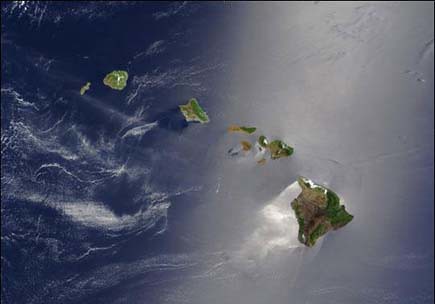
Hawaiian Islands
A silver swath of sunlight surrounds half of the Hawaiian Islands in this true-color Terra MODIS image acquired on May 27, 2003. Sunlight reveals turbulence in the surface waters of the Pacific Ocean. In this scene, the winds ruffling the water surface around the Hawaiian Islands create varying patterns, leaving some areas calmer than others. From lower right to upper left, the Big Island (Hawaii), Maui, Kahoolawe, Lanai, Molokai, Oahu, Kauai, and Niihau islands all make up the state of Hawaii, which lies more than 2,000 miles from any other part of the United States. The small red dot on the Big Island's southeastern side marks a hot spot on Kilauea Volcano’s southern flank
Palm Island, Dubai, United Arab Emirates
This IKONOS satellite image was collected on July 16, 2004. The image shows this man-made island that lies off the coast of Dubai in the Persian Gulf. The island is being built from 80 million cubic meters of land dredged from the approach channel to the Emirate's Jebel Ali Port. When complete, this resort will have approximately 1,200 single-family and 600 multi-family residences, an aquatic theme park, shopping centers, cinemas and more. 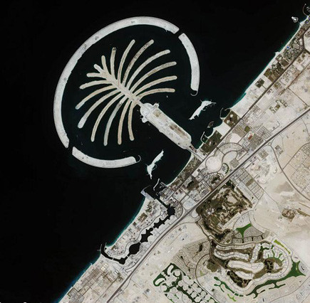
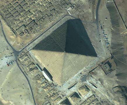
The Great Pyramid, Giza, Egypt
This featured image is a 61-centimeter pan-sharpened image of the Great Pyramid in Giza, Egypt, collected by QuickBird on February 2, 2002. The Great Pyramid is estimated to have been built circa 2650 B.C., and was erected as a tomb for the Egyptian pharaoh Khufu of the Fourth Dynasty. Upon the completion of its construction, the Great Pyramid stood 145.75 meters (481 feet) high, and over the millennia has lost approximately 10 meters (30 feet) off the top. It stood as the tallest structure on Earth for more than 43 centuries.
Ayers Rock (Uluru), Australia
This IKONOS satellite image of Ayers Rock was collected Jan. 17, 2004. Ayers Rock is located in Kata Tjuta National Park, 280 miles (450km) southwest of Alice Springs, Australia. It is the world's largest monolith, an Aboriginal sacred site and Australia's most famous natural landmark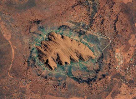
Earth’s City Lights
This image of Earth’s city lights, captured on October 19, 2000, was created with data from the Defense Meteorological Satellite Program (DMSP) Operational Linescan System (OLS). The brightest areas of the Earth are the most urbanized, but not necessarily the most populated. Cities tend to grow along coastlines and transportation networks. The United States interstate highway system appears as a lattice connecting the brighter dots of city centers. In Russia, the Trans-Siberian railroad is a thin line stretching from Moscow through the center of Asia to Vladivostok. The Nile River, from the Aswan Dam to the Mediterranean Sea, is another bright thread through an otherwise dark region.

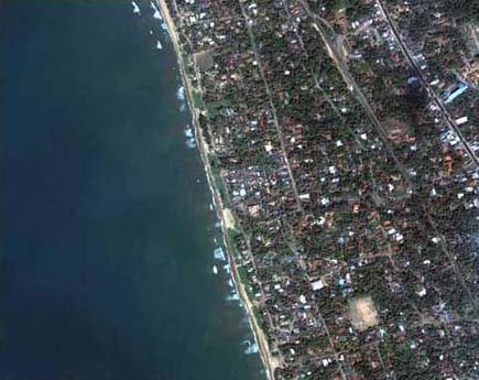
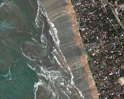
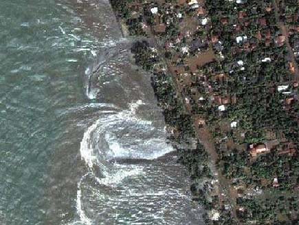
Tsunami strikes the coast of Sri Lanka
This is a natural color, 60-centimeter (2-foot) high-resolution QuickBird satellite image featuring the southwestern coast of Sri Lanka. Imagery was collected on December 26, 2004 at 10:20 a.m. local time, slightly less than four hours after the 6:28 a.m. (local Sri Lanka time) earthquake and shortly after the moment of tsunami impact.
Mount St. Helens, Washington
On a Space Station expedition, astronauts observed and captured this detailed image of the volcano's summit caldera. In the center of the crater sits a lava dome that is 876 feet above the crater floor and is about 3,500 feet in diameter. The dome began to form after the May 18, 1980 eruption of Mount Saint Helens. After the eruption, there was not any dome building eruptions for more than a decade. Afternoon lighting accents the flow features in the volcanic and debris flows and the steep valleys eroded into the loosely consolidated material near the summit. This picture was taken on October 25, 2002. 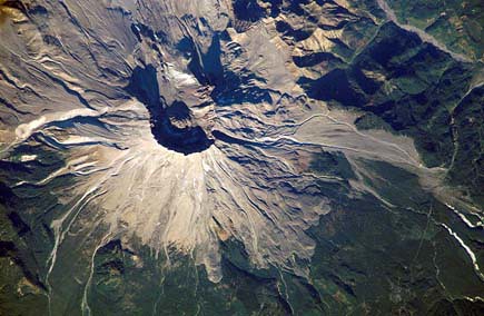
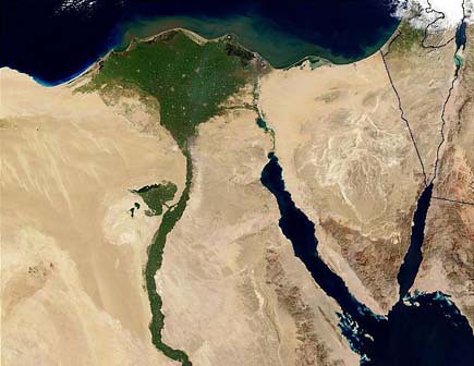
The Nile River
This image of the northern portion of the Nile River was captured by the Multi-angle Imaging Spectroradiometer's (MISR's) nadir camera on January 30, 2001. Against the barren desert of northeastern Africa, the fertile valley of the Nile River runs northward through Egypt. The city of Cairo can be seen as a gray smudge right where the river widens into its broad fan-shaped delta. Other cities are dotted across the green landscape, giving it a speckled appearance. Where the Nile empties into the Mediterranean Sea (top) the waters are swirling with color, likely a mixture of sediment, organic matter, and possibly marine plant life. Farther west, the bright blue color of the water is likely less-organically rich sediment, perhaps sand
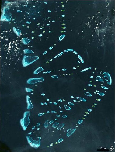
Malosmadulu Atolls, Maldives
North and South Malosmadulu Atolls are in the Maldives, an island republic in the northern Indian Ocean, southwest of India. The Maldives are made up of a chain of 1,192 small coral islands, which are grouped into clusters of atolls. It has a total area of 298 square kilometers and a population of about 330,000. The capital and largest city is Male, with a population of about 80,000. Arguably the lowest-lying country in the world, the average elevation is just 1 meter above sea level. The natural-color ASTER image of the Malosmadulu Atolls was acquired on December 22, 2002, and is centered near 5.3 degrees North latitude, 73.9 degrees West longitude
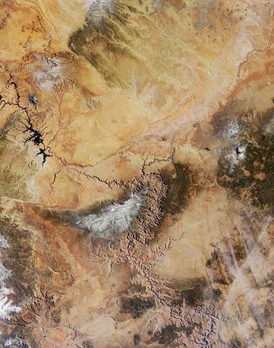
Grand Canyon
Northern Arizona and the Grand Canyon are captured in this pair of Multi-angle Imaging Spectroradiometer (MISR) images from December 31, 2000. The above image is a true color view from the nadir (vertical) camera. In addition to the Grand Canyon itself, which is visible in the western (lower) half of the images, other landmarks include Lake Powell, on the left, and Humphreys Peak and Sunset Crater National Monument on the right. Meteor Crater appears as a small dark depression with a brighter rim, and is just visible along the upper right-hand edge.
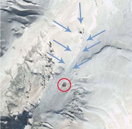
Noah's Ark Site
Is it or isn't it? Satellite images of Mt. Ararat, Turkey have pointed to a possible sighting of Noah's Ark. Decide for yourself! Compare this image taken by Digital Globe on September 10, 2003 with Shamrock ? The Trinity Corporation's image (enlarge). Also, note their image is flipped
Breathtaking Airport Terminals Around the World
Denver International Airport
At first glance Denver looks like a modern architecture version of a bedouin encampment, something that you might see at an airport in the Arab Emirates. But the Teflon coated pyramid shaped tent canopies are references to the white capped mountains behind. The effect is great. There are several conspiracy theories relating to the airport's design and construction. Murals painted in the baggage claim area have been claimed to contain themes referring to future military oppression and a one-world government. In the mid-1990s, Philip Schneider gave lectures about highly secretive government information concerning "deep underground military bases" that were constructed by the United States government, and said that one of these bases exists about two miles underneath the Denver International Airport. Author Alex Christopher claimed to have worked in the tunnels under the airport, and described what appeared to be vast holding areas for prisoners, strange nausea-inducing electromagnetic forces, and caverns big enough to drive trucks through, presumably to be filled with helpless political prisoners.

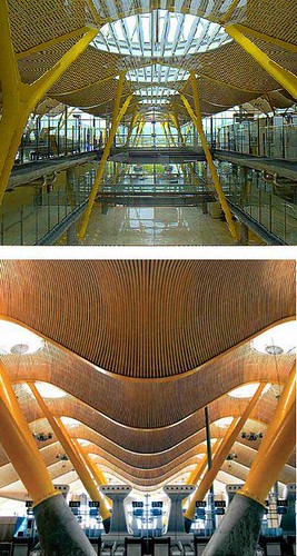
Madrid's Barajas International Airport Terminal 4.
The airport was first constructed in 1927, opening to national and international air traffic on April 22, 1931 and is the most important international and domestic gateway in Spain. Terminal 4, designed by Antonio Lamela and Richard Rogers (winning them the 2006 Stirling Prize) was inaugurated on February 5, 2006. Barajas has the world's largest single terminal area, with an area of more than one million square meters (11 million square feet). Consisting of a main building (T4) and satellite building (T4S), which are separated by approximately 2.5 km, the new terminal is meant to give passengers a stress-free start to their journey. This is managed through careful use of illumination, available by glass panes instead of walls and numerous domes in the roof which allow natural light to pass through
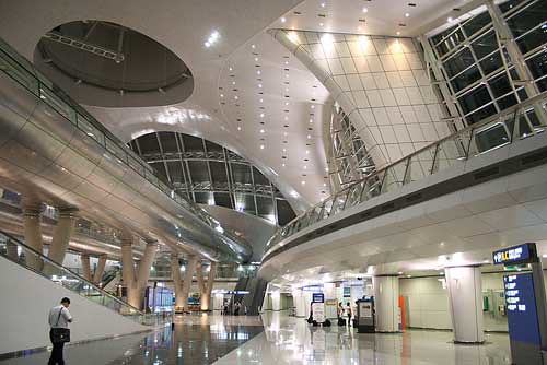
Incheon International Airport is the largest airport in South Korea, and one of the largest and busiest in Asia. Since 2006, it has been consecutively rated as the best airport in the world and received the full 5-star ranking by Skytrax, the prestigious recognition shared only by Hong Kong International Airport and Singapore Changi Airport. Although not all of the design of South Korea's Incheon airport is that remarkable, the 22 floor high control tower with its giant hall underneath is extremely impressive.
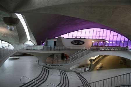
Saarinen's TWA terminal at JFK, designed by Eero Saarinen, it was sculpted as an abstract symbol of flight. It is considered one of the most architecturally distinguished airport terminal designs in the world It was the first airport terminal to rise to the level of an undisputed architectural masterpiece. Not only is its design unsurpassed, today, it is also still largely uncopied, despite it fame
Kuala Lumpur International Airport.
Situated 31 miles or about 50 km south of Kuala Lumpur, Kisho Kurokawa's new Kuala Lumpur airport synthesizes indigenous materials, forms and landscaping in an attempt to introduce diversity and complexity into a moribund typology.Looks like a disco, with all the reflections. 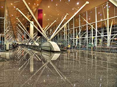
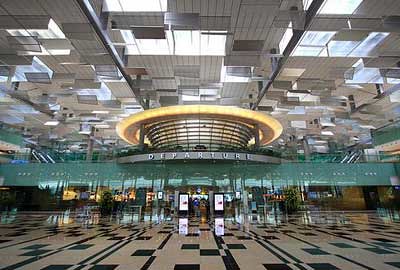
Singapore Changi Airport's Terminal 3 was officially opened on 9 January 2008. The S$1.75 billion terminal comprises 380,000 square metres of space and is the largest of Changi Airport's three terminals What makes Terminal 3 at Changi, which opened in 2008, interesting is that it marks a break from recent airport design, using rectilinear shapes and combining fabricated elements with natural textures .
Bilbao Airport.
Calatrava sometimes produces beautiful engineering rather than beautiful architecture, the emphasis being on the aesthetics of the structure, rather than the space, but Bilbao Airport shows a competent mix of the two.This exciting architecture is design by the architect Santiago Calatrava. The investment is 43 million Euros($39million). It covers an area of 25, 000 square meters and will be able to handle up 3 million passenger per year. 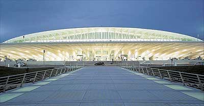
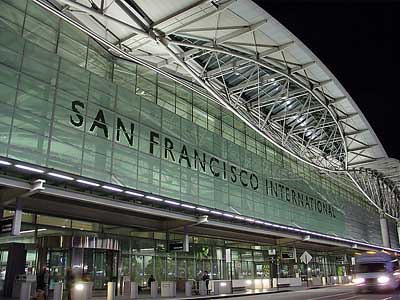
San Francisco International (SFO).
SFO's billion dollar international terminal, which opened in 2000, is the largest international terminal in North America, and the largest building in the world built on baseisolators to protect against earthquakes.
Kansai International Airport.
is an international airport located off the shore, in middle of the sea. It feels strange to land to it, because from plane windows, passengers can see only waves. During 60's Kansai region was losing trade to Tokyo, which had already good international connections. The original plan was to expand Osaka International Airport. But it could not be done, because it was already surrounded by tall buildings. The airport has a single terminal, reputedly the longest building in the world at 1.7 kilometres from end to end.

No comments:
Post a Comment